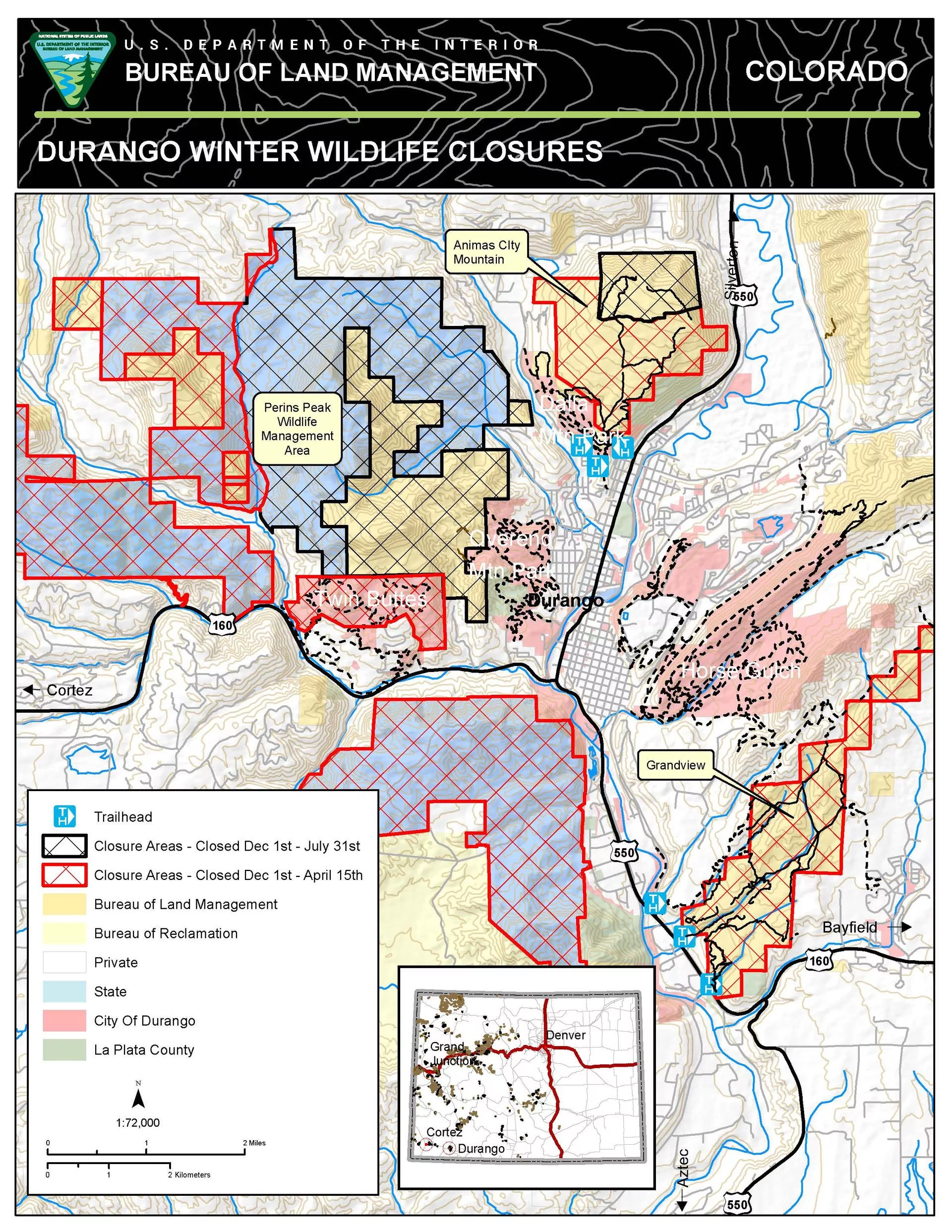
Seasonal Wildlife Closures
VIEW DURANGO WINTER WILDLIFE CLOSURE MAP
Colorado Parks and Wildlife seasonal wildlife closures are December 1 through April 15, with possible extension to April 30 if conditions warrant:
Grandview Ridge
- Big Canyon and Sale Barn trailheads (access located east of U.S. Highway 160)
- South Rim Trail, portions of Sidewinder and Cowboy trails on BLM accessed from Carbon Junction Trail
- Grandview BLM trails (access from Three Springs)
Animas City Mountain
- BLM lands above the lower loops (approximately 1.5 miles above the 32nd Street trailhead).
Twin Buttes Area
- All upper trails as marked.
Bodo State Wildlife Area
- Exception: Smelter Mountain Trail is open from 10 a.m. to 2 p.m.; dogs are prohibited. Small game hunting is allowed in the area south of La Plata County Road 210.
In addition, the Perins Peak area east of County Road 208 and west of Hogsback is closed through July 31 to protect nesting peregrine falcons. Closures near Cortez include the Aqueduct, Chutes and Ladders, the Summit areas within the Montezuma Triangle Recreation Management Zone and portions of the Cortez Special Recreation Management Area.
The following Durango-area trails will remain open for hiking, biking, snowshoeing, and skiing:
Horse Gulch, Telegraph, Crites, and Skyline areas
- Meadow, Stacy’s, Mike’s, Telegraph, Crite’s, and Sugar trails
- All of the Raider Ridge Trail to Medicine
- Ben’s Down and Out and Charmed trails
- Carbon Junction trailhead at Highway 3 to Telegraph via Crites Connection are open.
Lower Twin Buttes trails
- Access off of Highway 160 West; upper loops are closed.
All of Dalla Mountain Park
- Access off of Junction Creek Road.
Lower Twin Buttes trails
- Access off of Highway 160 West; upper loops are closed.
Overend Mountain Park
- Access at Leyden Street, Montview Parkway, Crestview Drive, and Hidden Valley Circle.
Trails around Fort Lewis College and along the Rim
- Lions Den, Chapman Flow, and Jump Line
Lower Twin Buttes trails
- Access off of Highway 160 West; upper loops are closed.
- The Rim, Squawker, Tawker, and Skyline trails (accessed from the Powerline Trail).
The Colorado Trail
- Access at Junction Creek.
A 1.5-mile loop trail on the lower portion of Animas City Mountain
- Access off of Highway 160 West; upper loops are closed.
- Access from the Birket Drive and 32nd Street trailheads or Dalla Mountain Park.
Durango Trails “Trail Conditions Report” is updated for winter including areas open for cross country skiing, fat biking and other winter related conditions. Please be sure to check the CAIC website and know before you go.
To learn more about seasonal wildlife closures, view a video produced by Durango Trails in partnership with Colorado Parks and Wildlife.