fbpx
single-t2k_trails.php

Animas Mountain Trail System BikingHikingTrail Running

Difficulty
,
Condition
Fair

Notes: 03.27.24 Early season conditions with scattered storms. Combination of dirt and wet spots. Upper Animas has seasonal wildlife closure through 4.15.

Region
Trail Length
5 miles
Distance from Durango
5 miles
Directions
Gain
1428 ft
Rating
0 Loves (log in or register to love this trail!)

Animas Mountain Trail System

Biking, Hiking, Trail Running
Durango to TH

5 Miles

Gain

1428 Feet

Condition

Fair

Region

Trail Length

5 Miles


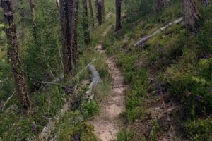
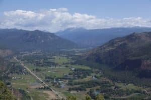
A popular and iconic trail in Durango, Animas Mountain yields spectacular views of the Hermosa (to the south) and Animas (to the north) Valleys. The main trail, Animas Mountain loop is very easy to follow via the many signs along the way.

Officially, this loop is a lollipop heading in a counter-clockwise direction. Ride/hike up the doubletrack for a few hundred yards from the parking area and take a right at your first trail junction. Keep taking right turns at all junctions to follow this loop in a counter-clockwise direction.

After 2.5 miles, you will reach the loop’s high point and a beautiful view of the Animas River Valley. The trail then descends 2.5 miles with great views of the La Plata Mountains to the west. The trail rejoins the “stick” of the lollipop at the bottom and down to the parking area where you started. Please note: The upper loop of Animas Mountain is closed for seasonal wildlife closures from December 1 to April 15.

Map & Directions

Map Coordinates: 37.302740, -107.872833

Where's the Trailhead?

dIRECTIONS TO TRAILHEAD

Main Trailhead (West 4th Avenue & 32nd Street)

Birket Drive Trailhead

To main trailhead:

From North Main Street, take a left on 32nd Street and then a right on West 4th Avenue, where you will see the parking lot/trailhead for Animas Mountain a short ways up.

Trailwork

help build our trails!

No upcoming trailwork events are currently scheduled.

Love the Trails Like a Local

Say Hi

Greet all trail users by saying hi when passing on the trail.

Announce Yourself

Say "on your left" as approaching other trail users from behind.

Pick Up After Yourself

Pick up after yourself and your pet. Please don’t litter.

Keep Dogs on a Leash

Keep your dogs on a leash or leave them at home. Off-leash dogs are not allowed on City Open Space and are the number one source of trail conflict.

Stay on the Trail

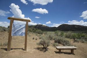
Help protect natural areas and habitats by staying on established trails. Creating "social trails", cutting switchbacks, or ignoring trail closures leads to greater erosion and impacts on ecosystems.

Give Uphill Traffic the
Right of Way

Uphill traffic always has the right of way. Downhill traffic must be in control, especially around blind corners, to avoid coming in contact with uphill traffic.

Check Conditions

Stay up to date by checking the Trail Conditions report and following us on Facebook or Instagram.

Give Back

Donate to Durango Trails or volunteer for trailwork to help give back to the trails you love.

Similar Trails

other trails you may enjoy

Support the trails that connect you to the outdoors

Trails are the cornerstone of our community and the gateway to the outdoors.

Help support our work so you can continue to connect to the outdoors by giving to Durango Trails!