Overend Mountain Park Trail System
Trails in this system
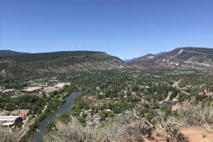
The main area of Overend Mountain Park encompasses about 300 acres, located right in-town of Durango. While those 300 acres do not make for a long bike ride, oh what a ride it is! The best way to describe Overend Mountain Park is as a “playground for mountain bikers.” With buttery singletracks, bridges, burms, banks, jumps and bumps, and trails crisscrossing through green forested gullies, there’s a reason Overend Mountain Park is a favorite place to ride among Durango locals.
Overend Mountain Park is accessible in all seasons, and is perfect for biking, hiking, and trail running in the summer and fall, as well as fat biking and snowshoeing in the winter.
Want to use the force? Try Star Wars and fly down the flume-like downhill with zigzags and banks to shake off any imperial tie fighters. Some of the upper trails like Hogsback, Grabens Loop, and Hidden Valley offer great views of the city looking east and awesome downhill descents.
Starting from the Ella Vita neighborhood on Ella Vita Ct., hop on the trail and take your first right at the road to head up to the La Plata County landfill. Before you start the climb, you’ll see a singletrack on your right. Follow that trail to your right and climb up, where you’ll cross a bridge and continue climbing up. Continue to follow the trail to your right, it will take you down 8 Bells, over to Perins Gulch. Turn right and follow the ditch trail, where you’ll see a trail continue right in front of you. Follow this to the Hidden Valley trail, where you’ll climb up, staying to your right. This will bring you to the top of Star Wars where you’ll encounter a steep descent, back to Perins Gulch. Climb up 8 Bells and go right and then around to the Spirit Trail. This will bring you back to where you parked.
History of Overend Mountain Park
The creation of Overend Mountain Park in the late 1990s was an impressive feat of private and public partnership. Ed Zink, Ned Overend and Scott Fleming owned land in the large swath of open space west of Durango, then known as the Test Track. Local cyclists had spent years exploring the area’s legendary singletrack and “testing” new mountain bike innovations.
At the same time, plans emerged to develop a large swath of property owned by Durangoans Jake Dalla and George VandenBerg. Zink and Overend were able to help the City of Durango negotiate the purchase of the land, and Trails 2000 went to work and raised $55,000, which the City matched for its first-ever open space purchase of 55 acres.
Included in the package were 15 miles of some of Durango’s most beloved trails. Trails 2000 conducted a complete overhaul to connect the trails in 2008 and built Hidden Valley, 8 Bells, and Ella Vita trails. Trails 2000 continues to maintain the trail network to this day.
Map & Directions
Map Coordinates: 37.292210, -107.889024
Where's the Trailhead?
dIRECTIONS TO TRAILHEAD
Hidden Valley Circle Trailhead
Crestview Street Trailhead
Leyden Street Trailhead
To reach the Hidden Valley Trailhead: From downtown Durango, head north on Main Street to 22nd Street. Turn left on 22nd Street, then right onto West 3rd Avenue, then left onto 23rd Street. Follow that as it becomes Columbine Drive, then turn left onto Arroyo Drive. Turn left onto Hidden Valley Circle and parking will be at the end of the cul de sac.
To reach the Crestview Street Trailhead: From downtown Durango, head north on Main Street to 22nd Street. Turn left on 22nd Street, then follow it around as it becomes Montview Parkway. Turn right onto Highland Avenue, then turn left onto Crestview Drive. Parking is at the end of the cul de sac.
To reach the Leyden Street Trailhead: From downtown Durango, head north on Main Street to 22nd Street. Turn left on 22nd Street, then follow it around as it becomes Montview Parkway. Turn left onto Forest Avenue, then turn right on Leyden Street. Parking is at the end of the cul de sac.
Love the Trails Like a Local
Say Hi
Greet all trail users by saying hi when passing on the trail.
Announce Yourself
Say "on your left" as approaching other trail users from behind.
Pick Up After Yourself
Pick up after yourself and your pet. Please don’t litter.
Keep Dogs on a Leash
Keep your dogs on a leash or leave them at home. Off-leash dogs are not allowed on City Open Space and are the number one source of trail conflict.
Stay on the Trail
Help protect natural areas and habitats by staying on established trails. Creating "social trails", cutting switchbacks, or ignoring trail closures leads to greater erosion and impacts on ecosystems.
Give Uphill Traffic the
Right of Way
Uphill traffic always has the right of way. Downhill traffic must be in control, especially around blind corners, to avoid coming in contact with uphill traffic.
Check Conditions
Stay up to date by checking the Trail Conditions report and following us on Facebook or Instagram.
Give Back
Donate to Durango Trails or volunteer for trailwork to help give back to the trails you love.