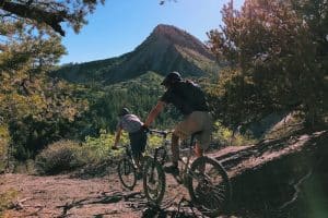
Twin Buttes Trail System has moderate steady climbs, tight banked turns and classic single track. While a popular mountain bike location, it is also a multi-use trail. It is located off Hwy 160 in Durango. There is a dirt parking lot near a gas station on the North side of the road. The main (East) trailhead is here and the second access trail is on Lightner Creek Road (CR 207) which will lead you east towards the main entry.
Featured trails: Ed and Flo for their twisty and whoopy turns.
From Durango, go west on Highway 160. After approximately 1.5 miles you’ll see a dirt parking lot near the Speedway gas station on the North side of the road. Turn right into the trailhead parking lot. You can also continue on Hwy 160 to the second access trail which is on Lightner Creek Road (CR 207).
Join us for a weekday trailwork party at [location TBD]. Thank you for volunteering with Trails 2000 at our trailwork party on Thursday, September 12 from 4:30 to 7:30pm!